We’re going to stop saying "polar vortex reversal"
We’re going to stop saying "polar vortex reversal"
Based on some questions from readers and from some stories we’ve seen online in the past month, we’ve come to realize that there may be some confusion about what our experts mean when they talk about there being a “reversal” of the polar vortex. Since my primary role on the blog is to notice when such confusion might happen and try to prevent it, I volunteered to do this unplanned post as penance for having failed to recognize that some of our previous explanations might not have been totally clear.
So, let me explain why we are going to stop saying 'polar vortex reversal.'
It’s a reversal
In previous posts, Amy and Laura explained that we can estimate the strength of the polar vortex by the westerly winds that occur high in the polar stratosphere in winter. The precise definition is the mean zonal wind at 60 degrees latitude (North or South) and 10 hPa altitude. (Zonal means “along a given line of latitude.”) On average, this prevailing wind is strongly westerly (from the west) in winter. So far, so good, hopefully no confusion.
The stratospheric polar vortex behaving itself very nicely on November 12, 2023, before planetary wave activity later in the winter started knocking it about. The prevailing (mean) flow of winds around the polar cap in the winter is strongly westerly (counterclockwise from a bird's-eye view). This animation is a screen recording from the earth.nullschool.net weather model viewer. It shows winds and temperature at the 10-millibar pressure level (about 19 miles/30 km in altitude). View additional days.
The possibility of confusion comes in when we start to talk about deviations from this background flow. Viewed one way, the definition of the polar vortex is tied to a specific location—the 60-degree latitude circle. When the zonal wind at this latitude drops to zero, it means the average circulation in the region usually occupied by the polar vortex is no longer westerly. Sometimes, the average wind at that latitude can even reverse to an easterly flow.
At times, we have described this easterly flow as “a reversal” of the polar vortex…which it is, if you’re thinking (as our experts usually are) of the polar vortex as the average circulation of the polar stratosphere at 60N. One common definition of a sudden stratospheric warming is, in fact, the reversal of winds at 60 North latitude and 10 millibars altitude.
But… if you are thinking of the polar vortex as a specific, dynamic feature of the atmosphere that is present on a given day and time, then talking about a “polar vortex reversal” paints the wrong picture of what is happening.
But it’s not a reversal
Dynamically speaking, the stratospheric polar vortex is a specific feature: a band of strong winds that separates polar air from mid-latitude air. Day to day, it doesn't perfectly overlie the 60-degree latitude circle. It can be stretched way out, or split in two. The westerly winds and the frigid, low-pressure air inside can be budged out of the polar region by a competing high-pressure, easterly circulation. Any of these happenings could lead to the average wind at 60 degrees being reversed from its normal westerly flow.
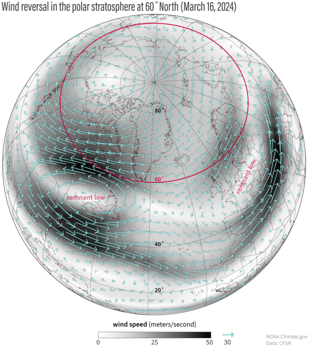
Following a polar vortex disruption in early March, winds at 60 degrees North (outlined in magenta) on March 16, 2024, were mostly from the east—a reversal of the normal wintertime circulation of the polar stratosphere. The remnants of the former vortex were pushed off the pole into the midlatitudes. The winds surrounding the remnants are still counterclockwise, the same direction as before the disruption, but much more localized. NOAA Climate.gov image, based on Climate Forecast System Reanalysis data provided by Laura Ciasto.
But the specific “version” of the polar vortex that existed near 60 degrees latitude before a disruption hasn’t reversed in the sense that it quit spinning one way and started spinning the other. After the vortex has been knocked off the pole or pulled apart, the wind around the remaining remnants still flows the same direction as before, but these features are much smaller spatially than before the disruption, and typically shifted off the pole. The remnants may either dissipate or merge into the new version of the polar vortex as it re-forms at 60 degrees.
Ambiguity
Basically what it comes down to is your frame of reference, and whether you’re thinking of the polar vortex as the conditions in a specific place or as a discrete phenomenon. Given some of the stories we have seen attributed to the blog this winter, we think we haven’t been clear enough that when we talk about a “reversal,” we are talking about a reversal of the mean winds at 60 degrees.
When the stratosphere is behaving itself, these winds are westerly, and we describe them as the polar vortex. When the stratosphere is jostled, that circulation may break apart, drift away, or be swallowed up by other activity. But the remnant or remnants themselves don't literally reverse. Instead, a new, reversed circulation can form at 60 degrees, where the polar vortex previously was.
So… you should definitely not be picturing a stratospheric hurricane suddenly spinning backwards…no matter how much cooler that would be. There’s a saying about scientific explanations that’s often attributed to Albert Einstein: “Everything should be made as simple as possible, but not simpler.” Saying ‘polar vortex reversal’ probably crossed that line. We’re sorry about that.
Going forward we are going to stop using the expression “polar vortex reversal” and stick to exact language: a reversal of the winds at 60 degrees. I am also going to go back to every old post and correct (and note) any previous uses of the ambiguous phrase. Feel free to use the comments of old posts to help me find them!