U.S. climate outlook for March 2025
Winter retained its icy grip across much of the northern portions of the United States during February, with temperatures across the Northern Rockies averaging more than 10°F below normal. Even farther east, where February temperatures were only slightly below average, a few Arctic blasts during the month had folks anxiously awaiting the end of the winter. For the winter as a whole across the entire nation, this was likely the coldest winter in at least 10 years, with much of the central and eastern parts of the nation recording below-normal temperatures.
Precipitation during February was more of a mixed bag, with beneficial rains and snows falling across the Pacific Northwest, too much rain impacting the Ohio and Tennessee Valleys, and too little rain falling across the Southern Plains and in the Southeast. As we head into the beginning of meteorological spring, will Punxsutawny Phil be correct that winter will persist through much of March? With more than 40% of the nation currently experiencing some degree of drought and about 2/3 at least abnormally dry, will beneficial precipitation begin to whittle those numbers down? Here’s what NOAA’s Climate Prediction Center (CPC) thinks will happen during March.
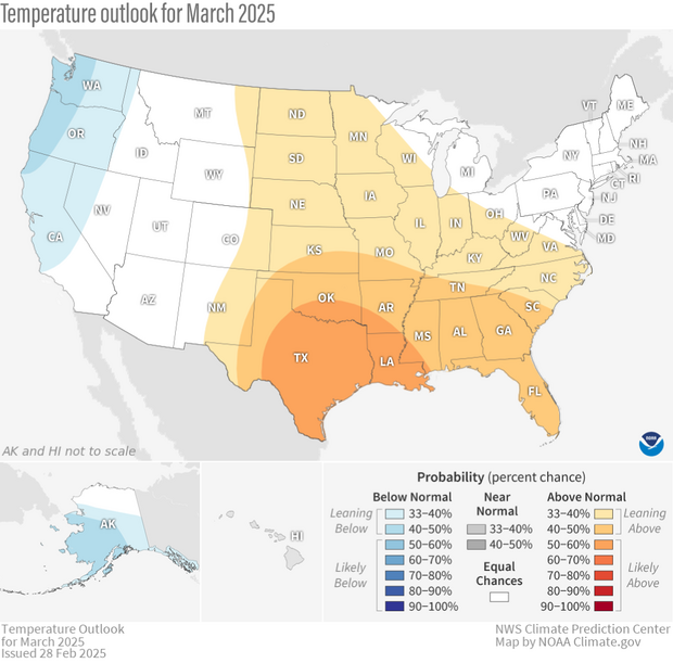
The U.S. temperature outlook for March 2025, showing where the monthly temperature is favored to be much warmer than average (orange and red) or much cooler than average (blues). Darker colors mean higher chances, not more extreme temperatures. White areas mean that there are equal chances for a warm, cool, or near-average March. Much warmer or much cooler than average means "in the upper or lower third" of average March temperatures from 1991-2020. Text-only forecast for Hawaii available from NOAA Climate Prediction Center.
On February 28, CPC released its monthly climate outlooks for temperature, precipitation, and drought across the United States for March 2025. The temperature outlook favors well above average temperatures across much of the southern and eastern parts of the nation, with the exception of in the Northeast. Below-average temperatures are favored across parts of the western U.S. and central and southern Alaska. The precipitation outlook favors well above average precipitation in parts of the West and around the Great Lakes, in the Ohio Valley, in parts of the Northeast, as well as in western and southern Alaska, with below-average precipitation favored in parts of the Southwest and Southern Plains.
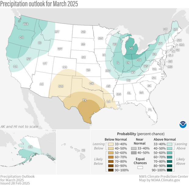
The precipitation outlook for March 2025, showing where the average precipitation (rain and snow) is favored to be much higher than average (greens) or much lower than average (browns). Darker colors mean higher chances, not more extreme precipitation departures. White areas mean that there are equal chances for a wet, dry, or near-average March. Much higher or much lower than average means "in the upper or lower third" of total March precipitation amounts from 1991-2020. Text-only forecast for Hawaii available from NOAA Climate Prediction Center.
During the rest of this post, I’ll discuss the basis for the outlooks and provide more specific information about them, talk about the changes in drought that occurred during February, and provide the drought outlook for March. Finally, remember that the colors on the temperature and precipitation outlook maps provide information about the most likely outcome, but other outcomes are still possible, just less likely. More details about interpreting the outlooks can be found here.
The monthly outlooks were produced considering the Week 1 forecast from the Weather Prediction Center (WPC), and CPC’s own 6-10 day, Week-2, and Week 3-4 outlooks. Other tools that forecasters examined this month included longer-range forecast models such as the Global Ensemble Forecast System (GEFS), the Climate Forecast System (CFSv2), and the European Ensemble Forecast System (ECMWF) as well as products derived from these models. With a weak La Niña hanging around, it played at least a minor role in the outlooks for March. The Madden-Julian Oscillation (MJO) was weak at the end of the month, and with disagreement seen among the main computer models on its future evolution, the main contribution from this potential source of predictability was to inject additional uncertainty into the outlooks.
March outlook tilts toward mild temperatures in the South and parts of the North
The March temperature outlook favors well above average temperatures across much of the central and eastern parts of the nation. (Well above average means “in the warmest third of all Marchs in the recent climate record.”) Below-average temperatures are favored in the West and in much of Alaska. The shorter-term forecasts (i.e., the first 2 weeks of the month) imply a transient pattern, bringing a large degree of variability across the country early in the month. The pattern is anticipated to become more persistent by the middle of the month, with troughing (jet stream shifted south of normal) along the West Coast and weak ridging (jet stream shifted slightly north of normal) over the South and East, with the ridge axis located just off the East Coast.
This pattern tilts the odds toward below-normal temperatures along the West Coast, although with modest probabilities less than 50%. A significant swing in the jet stream pattern and temperatures is also expected during early March over Alaska. Shorter-term forecasts favor a rapid switch from above-normal to below-normal temperatures as troughing is expected to move into the region and then to persist into the Week 3-4 period. In contrast, forecasts favoring above-average temperatures have been fairly consistent over the north-central, central, and southern parts of the nation, which leads to elevated probabilities for warmer-than-average temperatures, with the largest probabilities in the south-central U.S. Variability in the East, particularly early in the month, results in modest probabilities slightly favoring above-average temperatures in the South and no tilt in the odds toward any category in the Northeast (equal chances of above-, below-, or normal temperatures).
March precipitation resembles La Niña composite, with wet across parts of the North and dry across the Southern Plains
For the 3rd month in a row, the monthly precipitation outlook resembles a La Niña-like response over the key winter/spring teleconnection regions of the U.S. Specifically, the March outlook favors above-average precipitation in the Pacific Northwest, across the Northern Rockies, and in an expansive area which includes some of the Mississippi Valley, the Great Lakes region, the Ohio Valley, interior portions of the Mid-Atlantic and Northeast. Above-average precipitation is also favored in western and southern Alaska. The best odds for a wetter-than-average March are around the Great Lakes (50-60%), although above-average precipitation is favored across all of these regions during much of the month.
Below-normal precipitation is favored over parts of the Southwest and Southern Plains, with good model consistency throughout the month. Models also tilt toward below normal along the Gulf Coast and Florida, consistent with might be expected with an ongoing La Niña. However, there is a decent chance for above-normal precipitation early in the month, so the forecast for this region does not favor any category.
U. S. Drought area increases during February
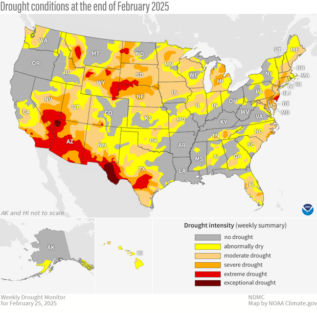
Drought conditions across the contiguous United States as of February 25, 2025. Drought conditions ranges from "abnormally dry" (yellow) to "exceptional" (dark red). Map by NOAA Climate.gov, based on data provided by the U.S. Drought Monitor project.
Drought coverage across the country increased slightly during the month, with coverage increasing from slightly less than 40% at the end of January, to about 41.5% at the end of February. The percent of the country in the two most intense categories (D3-D4, representing extreme and exceptional drought) also increased, from about 5% to just over 7%.
Regionally, drought changes were a mixed bag, with improvements observed in parts of the Northern Plains, the Southeast, and in the Mid-Atlantic, while degradation occurred in parts of the Southwest and Southern Plains, the Midwest, and from South Carolina to Florida. However, almost all changes were modest, generally on the order of 1 or 2 classes. Not surprisingly, degradation was associated with a drier-than-average February, while improvement (particularly in the Southeast) was associated with large precipitation surpluses during the month.
Drought Outlook predicts persistence and development across the South; limited improvement across parts of the North
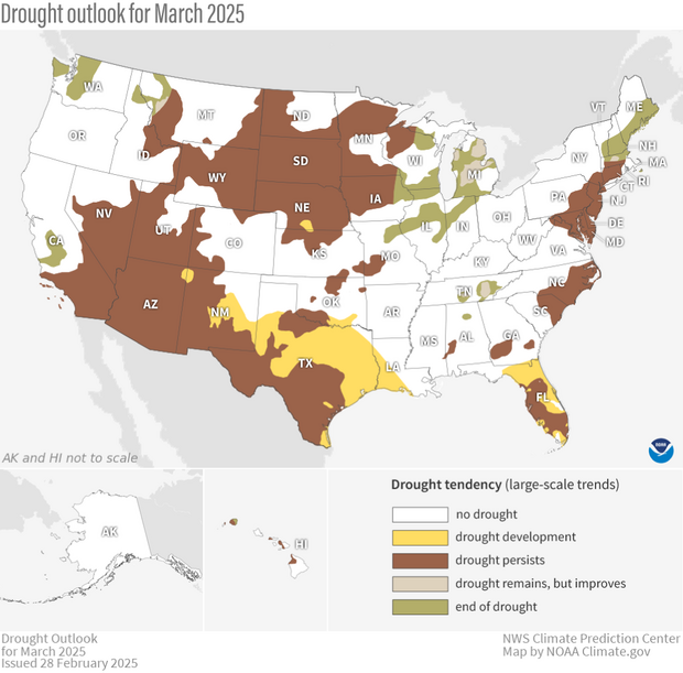
U.S. map of predicted drought changes or persistence in March 2025. NOAA Climate.gov map, based on data from the Climate Prediction Center (CPC). See CPC version for Alaska and Hawaii.
With a typical La Niña precipitation pattern favored across the northern parts of the country, drought reduction (and often removal) is likely across parts of the Pacific Northwest, Midwest, Tennessee Valley, and parts of New England. Persistence is likely throughout much of the High Plains, given a precipitation outlook with no tilt in the odds towards any category (equal chances of above-, below-, or normal precipitation) and the fact that March is a drier time of the year in this region. Drought persistence is also likely along the East Coast from Massachusetts southward, with extremely low stream flow observed and the outlook not favoring a wetter-than-normal month.
With odds favoring below-average precipitation across parts of the Southwest and Southern Plains, drought persistence and some development is likely during the month, especially across much of central and northern Texas. (Given the dry conditions, residents might want to keep an eye on fire weather outlooks from NOAA’s Storm Prediction Center this month.) Drought is also expected to persist and develop in much of Florida, where an abnormally dry winter is combined with outlooks favoring above-normal temperatures and an uncertain precipitation outlook.
To read the entire discussion of the monthly climate outlooks from the Climate Prediction Center, check out their website.