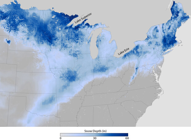
As January became February, Arctic air spilled southward into the United States and collided with a plume of moisture traveling north from the Gulf of Mexico. Widespread blizzard conditions slathered snow and ice across the Great Plains, the upper Mississippi Valley, the mid-Atlantic, and the Northeast. This map shows the estimated snow depth across the United States on the morning of February 2, 2011, as the storm was winding down across the Northeast.
Snow was 2 feet deep or more across large swaths of the country on Groundhog Day. For more southerly locations (Texas, Oklahoma, Arkansas, southern Missouri, and southern Kansas), virtually all of the snow was from the recent storm. (Images from NOAA’s National Snow Analysis show snow-free conditions across the Southern Plains in the last week of January). Farther north, this storm’s heavy snowfall piled on the remains of several prior storms that have affected the Northern Plains and the Northeast this winter.
This is the second consecutive very wintry winter in the eastern United States. Last year, NOAA climate scientists concluded the record-breaking snowstorms most likely resulted from the combination of two natural climate patterns: El Niño and the Arctic Oscillation.
So what about this year? Last winter’s El Niño has flipped to La Niña, as temperatures in the eastern tropical Pacific have been cooler than normal. But the Arctic Oscillation seems to be in a repeat pattern, with conditions this December and January very similar to last winter, according to Deke Arndt, Chief of the Climate Monitoring Branch at NOAA’s National Climatic Data Center.