Blogs

Most of us learned as children that the age of a tree could be found by counting its rings. Rings of trees growing in temperate climates can indeed tell their age through their annual rings and also help determine the age of wood used to construct buildings or wooden objects. The ages of wooden objects can be revealed by cross-dating, the process of matching ring patterns between wood samples of known and unknown ages.
What do tree rings tell us
The underlying patterns of wide or narrow rings record the year-to-year fluctuations in the growth of trees. The patterns, therefore, often contain a weather history at the location the tree grew, in addition to its age. In dry environments…
Read article

It’s been a busy fall with a potential El Niño in the forecast, but I was lucky enough to get the opportunity to participate in a recent conference on ENSO in Guayaquil, Ecuador. So, I brought along my trusty blogging laptop and want to share with you the latest on all things ENSO.
This meeting included around 130 scientists from around the world who are all studying different aspects of ENSO… imagine a professional Comic-Con for ENSO nerds and you’ll be roughly in the ballpark. But, no, I did not wear a Chris Farley El Niño-style wrestling cape.
One of the best aspects of these conferences is the chance to finally …
Read article
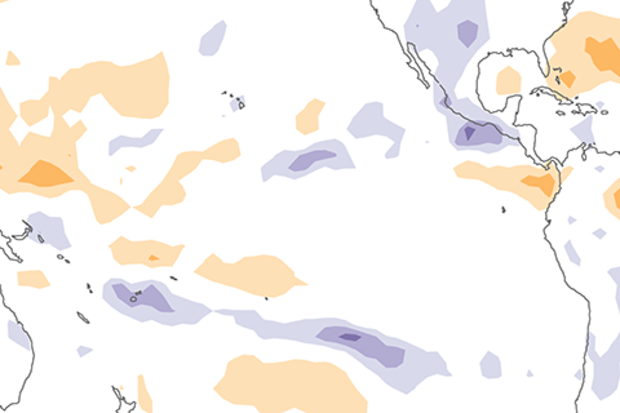
The surface of the east-central tropical Pacific is nearly 1°C warmer than the long-term average! We haven’t seen the atmospheric response that characterizes El Niño conditions quite yet, though. Forecasters estimate about an 80% chance that El Niño will form soon, and continue into the spring.
Where do I begin
Let’s run the numbers! All four of the ENSO monitoring regions in the tropical Pacific were warmer than average in October. The Niño3.4 region was 0.8°C warmer than average using the ERSSTv5 dataset with the long-term trend removed, comfortably above the El Niño threshold of 0.5°C above average.
To qualify as El Niño conditions, though, we have to see evidence that …
Read article
For about 20 years, the National Centers for Environmental Information (NCEI; formerly known as the National Climatic Data Center) has released a monthly Global Climate Report. The report can be described as Earth’s health assessment, where we as climatologists look into Earth’s "vitals" and place them into context by explaining what happened and how the recent vitals compare with older records. The current vital signs addressed in the report are temperature and precipitation.
Climatologists don’t make house calls, but we do provide answers about why keeping track of Earth’s vitals is so important. Here’s a quick Q&A.
Why is it important to have a monthly global climate report?…
Read article
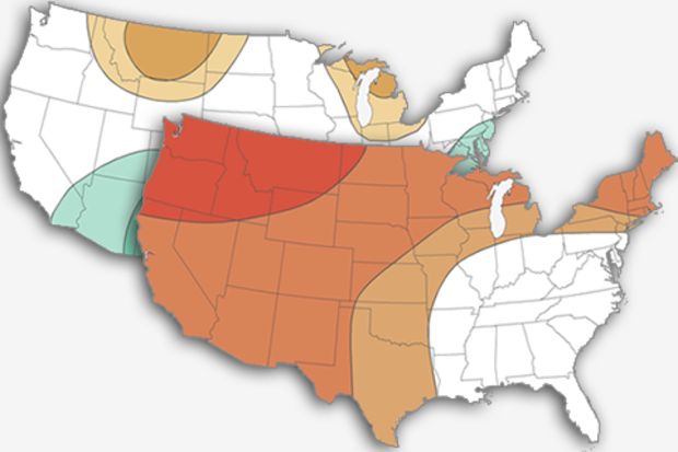
The air is starting to feel crisp, the leaves are changing, and the aroma of pumpkin spice lattes are filling your favorite coffee shops. This can only mean one thing – it’s time for my annual post on NOAA’s expectations for the upcoming winter! And once again, one of the key players is found in the tropical Pacific. In contrast with the last two years, when we were looking at potential La Niña development, this year we’re waiting to see if El Niño will arrive in time to impact winter. Without further ado, let’s take a look at NOAA’s 2018-19 Winter Temperature and Precipitation Outlook and see how ENSO has affected this forecast.
As usual: Outlooks are probabilisti…
Read article