Blogs
This is a guest post by Breanna Zavadoff and Marybeth Arcodia. Dr. Zavadoff is an Assistant Scientist at the University of Miami Cooperative Institute for Marine and Atmospheric Studies. Her current research focuses on U.S. West Coast atmospheric rivers as well as subseasonal Madden-Julian Oscillation predictability. Dr. Arcodia is a Postdoctoral Researcher at Colorado State University working in the Barnes Group. Her current research explores sources of climate predictability from subseasonal to decadal timescales using explainable artificial intelligence techniques. She also writes for the Seasoned Chaos blog, a subseasonal to seasonal forecasting blog for scientists and non-scientists ali…
Read article
As our regular readers will be very aware, La Niña has been rolling along in the tropical Pacific for many months, and our third La Niña winter in a row is under way. La Niña is the cool phase of the El Niño-Southern Oscillation (“ENSO” for short) climate pattern. The current forecast is for La Niña to continue into the winter, with 50-50 chances for La Niña and neutral in the January–March average.
Conditions in the tropical Pacific ocean-atmosphere system have been consistent with La Niña for long enough that, in November, one of our frequent readers commented—accurately—that they might as well have just re-read the October post! However, while La Niña seems stuck in a rut right now, th…
Read article
While it’s a little intimidating to put on these oversized shoes, I’m forging ahead in an annual ENSO Blog tradition and giving you all the juicy details about NOAA’s Winter Outlook (1). Regular readers may remember that Mike Halpert of the NOAA Climate Prediction Center (CPC) has been the blog’s winter outlook guru for years, but following Mike’s retirement earlier this year, I’ll be leading you on this year’s journey (Mike, I will try to make you proud!). And maybe my job will be pretty easy this time, given that we are expecting a third consecutive winter with La Niña conditions in the tropical Pacific. What will that mean for this winter? Let’s find out!
Double encore
Winter Outloo…
Read article
It’s very likely that La Niña will last through the winter (December–February), with a transition to ENSO-neutral (neither La Niña nor El Niño) expected during February–April. Specifically, there’s a 76% chance of La Niña through the winter and a 57% chance of neutral in the February–April period.
High reps
Acronym time! ENSO, the El Niño/Southern Oscillation (the entire El Niño and La Niña system), modifies global weather and climate in somewhat predictable ways. Since ENSO itself can be predicted several months in advance, it gives us an early picture of potential global rain, snow, and temperature patterns, among other climate effects. Check out my September post for a round-up of…
Read article
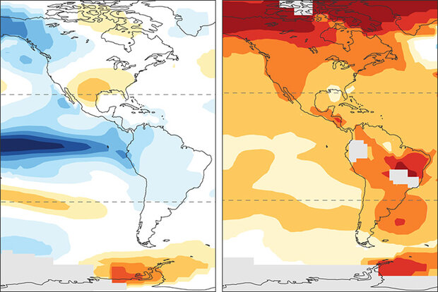
Here at the ENSO blog, we’ve been talking about La Niña (the cool phase of the El Niño-Southern Oscillation climate pattern) for going on three years now. People have started to tell us they’re bored ask us whether all these La Niñas could offset global warming. The short answer is no, La Niña is no match for global warming. (Footnote 1)
The simplest evidence is that global average temperature during recent La Niña years is warmer than for El Niño years in earlier decades! In fact, the La Niña year of 2020 tied 2016—a year that started with a major El Niño—as the all-time-record-high global surface temperature.
But if global warming continues year after year regardless of La Niña, …
Read article
