ENSO Blog
If it’s October, it must be time for my annual blog post detailing NOAA’s forecast for the upcoming winter. And as always seems to be the case (well not in 2015), we’re still trying to figure out what will happen across the tropical Pacific. Here I look ahead to provide some insight as to what is most likely to occur during the upcoming winter with regards to both precipitation and temperature.
Standard reminder: probabilities are not certainties
Before discussing the outlooks, I do want to remind readers again that these forecasts are probabilities (% chance) for below, near, or above-average climate outcomes with the maps showing only the most likely outcome (1). Because the probabil…
Read article
The task of a climate forecaster is to see the forest, and not get hung up on the individual trees. Especially that extra tall one over there, with the gnarl that looks like a face, and the low branches that would be so easy to climb, and… uh, right. My point is that we try to look beyond shorter-term weather to see longer-term monthly and seasonal patterns. After all, a particular winter can have several colder-than-average days and still be warmer than average overall.
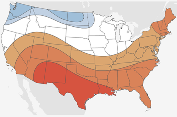
Which brings me to the current situation in the tropical Pacific! The October ENSO forecast says La Niña conditions are favored during the fall and winter 2017-18, but at press time the ocean-atmosphere system didn’t…
Read article
You may be thinking “There are even more things that forecasters look at when making seasonal forecasts?” or “Haven’t you already written about those other things, multiple times?” And the answer to both of those questions is yes. But what if I told you that there is another mysterious thing that, at least for seasonal temperature outlooks, gives forecasters a better idea of what will happen than predictions of ENSO or the Madden Julian Oscillation, or the Arctic Oscillation or the North Atlantic Oscillation or the Pacific Decadal Oscillation or…I think you get the point (1). And it’s much simpler than all of those. It’s called the trend.
Cool, another vaguely science sounding term. W…
Read article
The September ENSO forecast is out!! (Can you tell I’m excited to be back on the top-of-the-month post?) Forecasters think there is an approximately 55-60% chance of La Niña this fall and winter, so we’re hoisting a La Niña Watch. Read on to find out what’s behind this development!
Summer summary
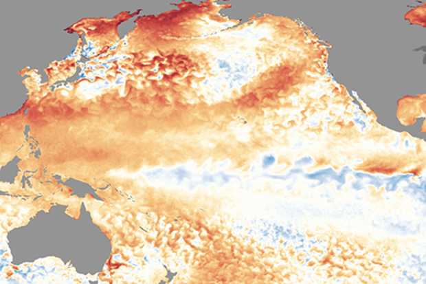
First, though, a quick recap of current conditions in the tropical Pacific Ocean. The sea surface temperature in our favorite Niño3.4 region in the central Pacific was about 0.1°C colder than the long-term average over June – August, smack-dab in the neutral range. The atmosphere also reflected neutral conditions during the summer, with the winds above the equatorial Pacific neither particular…
Read article
This is a guest post by Dr. Phil Klotzbach of the Colorado State University Department of Atmospheric Science. Dr. Klotzbach has been the lead author of CSU’s seasonal hurricane forecasts since 2006.
A large number of groups, including government agencies (see NOAA hurricane forecast), universities, and private sector companies, currently issue Atlantic basin seasonal hurricane forecasts. Dr. William Gray pioneered seasonal hurricane forecasts for the Atlantic in 1984, and our group at Colorado State University has issued predictions every year since that time.
Over 20 publicly available forecasts are displayed on a website that our group co-developed with the Barcelona Sup…
Read article