ENSO Blog
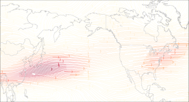
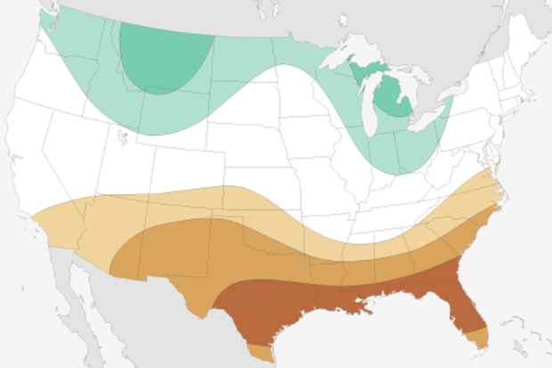
As Emily wrote two weeks ago, weak La Niña conditions are present and favored to continue through mid-winter of 2017. Even though the La Niña is weak and not expected to last very long, it is only fair here at the ENSO blog to give it and its impacts to the jet stream and to the United States some further elaboration.
So what about La Niña?
Yeah! What about La Niña? Can’t we show some love to the flip side of El Niño. In a previous post, Tony described, in detail, how El Niño can lead to global impacts through strengthening the Hadley Circulation where air rises near the equator, spreads towards the poles and sinks back to the surface in the subtropics (~30°N/S). This strengt…
Read article
La Niña’s clinging on by her fingernails! If last year’s big El Niño was likened by some (not us) to a certain monster lizard, this La Niña is more like a gecko. Weak La Niña conditions were present during November, and are favored to continue through the mid-winter. It’s looking more likely that the tropical Pacific will transition to neutral conditions by the January – March period.
The temperature of the ocean surface in the Niño3.4 region in the east-central tropical Pacific was about 0.9°C below average during November using the ERSSTv4 data set, and the September – November period was about 0.8°C below average. This is the third three-month period in a row below the La Niña threshol…
Read article
This is a guest post by Prof. Daniel J. Vimont (@DanVimont) of the University of Wisconsin Center for Climatic Research. His group focuses on mechanisms of climate variability and change, the intersection between weather and climate, and global and regional impacts of climate change. Apparently, he also likes to fly fish.
One of the things that climate scientists (not to mention disgruntled California residents who had been hoping for a drought-buster) can’t stop talking about is how the strong El Niño of 2015-16 just didn’t act like previous El Niños in many respects. Part of that discussion involves other climate patterns that operate in the Pacific Ocean and how they work to enhance o…
Read article
Let’s take a tour through the La Niña diagnostic flowchart…
Is the sea surface temperature in the Niño3.4 region more than half a degree cooler than average? Yes! (It was about -0.7°C below average during October.) Do forecasters think it will stay cooler than that threshold for several overlapping three-month periods? Yes! (But just barely.) Finally, are there signs that the atmospheric circulation above the tropical Pacific is stronger than average? Yes! This all means that La Niña has officially arrived.
First things first
The Niño3.4 Index—the temperature of the ocean surface in a specific region of the equatorial Pacific, and our primary metric for measuring El Niño and La …
Read article
Will we or won’t we see La Niña emerge this year? Does it even matter? Shoot, if one of the strongest El Niño episodes in history didn’t deliver much drought relief to California last winter, what are the chances for significant improvement this year? I’ll attempt to answer these and other questions here in my 5th blog post. If you'd rather watch a video recap of the winter outlook, we have that, too.
This blog is brought to you by the letter p, for “probability”
So what might influence our climate this winter? As you know from the ENSO blog, there is a link between the fall and winter conditions across the tropical Pacific and the average winter climate in …
Read article