Earth's surface temperature has risen about 2 degrees Fahrenheit since the start of the NOAA record in 1850. It may seem like a small change, but it's a tremendous increase in stored heat.
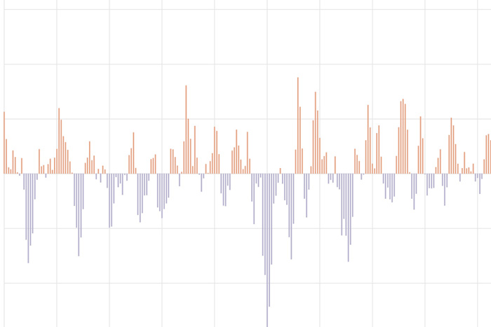
The Arctic Oscillation (AO) refers to an atmospheric circulation pattern over the mid-to-high latitudes of the Northern Hemisphere. The most obvious reflection of the phase of this oscillation is the north-to-south location of the storm-steering, mid-latitude jet stream.
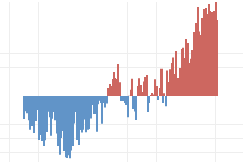
The Oceanic Nino Index tracks the sea surface temperature in the east-central tropical Pacific Ocean. It is NOAA's primary indicator of the climate patterns known as El Niño and La Niña.
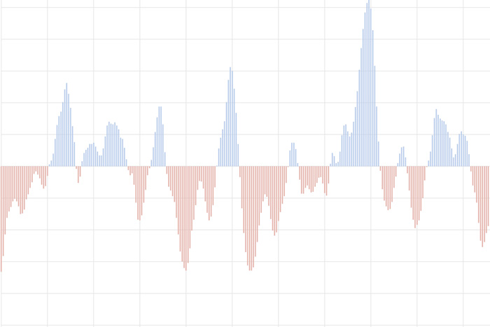
The North Atlantic Oscillation tracks a seesawing of surface pressure between two parts of the North Atlantic. Different phases often bring predictable changes in winds, temperature, and precipitation in the United States and Europe.

Susan Solomon Wins 2009 Volvo Environment Prize
January 15, 2009
Our blogger gives us a sci-fi themed update on the status of ENSO. Can you count all the references?
Many people will say “climate is the average of weather.” That’s not wrong, but it’s not a complete explanation.
It’s March Madness, ENSO style! Our blogger discusses why the North American precipitation pattern this past winter looked more like the response to a moderate-strength La Niña than to a weak event.
Why no one should expect a perfect match between what happens during a La Niña winter and the expected La Niña pattern. But knowing whether it may be a El Niño or La Niña winter is still useful!
The expected La Niña has been slow to develop. There's still a 57% chance it will emerge soon, and the atmosphere is already looking a bit like La Niña. Our blogger discusses some of the climate conditions at work in the tropical Pacific.